
Shop Products
- Gift Cards
- Apparel & Footwear
- Appliances
- Automotive
- Building Materials
- Cleaning
- Doors & Windows
- Electrical
- Hardware
- Fasteners
- Flooring
- Home Goods & Decor
- Heating, Cooling & Ventilation
- Holiday
- Lighting & Ceiling Fans
- Kitchen & Bath
- Lawn & Garden
- Paint
- Plumbing
- Outdoor Living
- Storage & Organization
- Pet & Wild Bird
- Sports & Recreation
- Tools
Services
Inspiration
About Us
Contact Us
Rewards
- Home
- Products
- Home Goods & Decor
- Office & Store Supplies
- Books, Maps & Planners
- Maps
- Sky Terrain 0-9665508-6-2

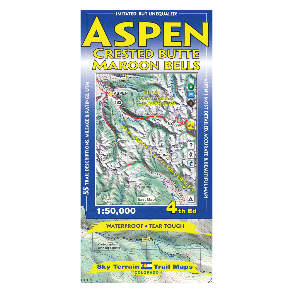
Sky Terrain 0-9665508-6-2 Trail Map, Ashcroft, Aspen, Capitol Peak, Castle Peak

Promo Price:
Sky Terrain 0-9665508-6-2 Trail Map, Ashcroft, Aspen, Capitol Peak, Castle Peak
The map is 1, 50,000 scale and covers Ashcroft, Aspen, Capitol Peak, Castle Peak, Crested Butte, Conundrum Hot Springs, Frigid Air Pass, Gothic, Government Trail, The Grottos, Hunter Valley, Independence Pass, Marble, Maroon Bells, Oh-be-Joyful, Pearl Pass, Pyramid Peak, Redstone, Ruby, Rustler Gulch, Schofield Pass, Snowmass, Taylor Park and Pass, Yule Quarry and oh so much more. (A total of 18 USGS quad maps.) The two maps cover seven lofty 14,000 ft peaks Capitol Peak, Castle Peak, Conundrum Peak, Maroon Peak, North Maroon Peak, Pyramid Peak and Snowmass Mount. The map shows large swaths of the White River National Forest and the Gunnison National Forest. A small slice of the San Isabel National Forest runs along the eastern edge of the map. The vast majority of the Maroon Bells Snowmass Wilderness is shown, while huge chunks of the Collegiate Peaks Wilderness and Raggeds Wilderness are also mapped. The whole SW section of the Hunter Frying pan Wilderness, including the namesake headwaters are well revealed. And a big bit of the Mount Massive Wilderness stands out above Half-moon Creek. In short, you should see the map to see the amazing territory covered. Extensive field scouting and research went into designing this map. The result is an accurate and up-to-date trail map packed with information. Several trails are published here for the first time. Historical routes are also shown.
| Continental Coverage | Ashcroft, Aspen, Capitol Peak, Castle Peak, Conundrum Hot Springs, Crested Butte, Frigid Air Pass, Gothic, Government Trail, Hunter Valley, Independence Pass, Marble, Maroon Bells, Oh-be-Joyful, Pearl Pass, Pyramid Peak, Redstone, Ruby, Rustler Gulch, Schofield Pass, Snowmass, Taylor Park/Pass, The Grottos, Yule Quarry |
- Two maps cover 9 USGS quads
- Shading tints and contours enhance elevation cues and organize complex terrain
- Backcountry ski huts
- Singletrack symbols for mountain biking
- Trail descriptions including directions, trail lengths, elevation gains, noteworthy features and more
- Historic routes shown for reference
- Ideal contour levels (80 ft) set to improve visualization of terrain forms and maximize elevation information
- Careful mapping and graphic stressing of natural hydrography to improve comprehension of the terrain forms
- Full UTM grid for easy use with GPS receivers
- Printed on waterproof, tear tough material for years of hands-on use