
Shop Products
- Gift Cards
- Apparel & Footwear
- Appliances
- Automotive
- Building Materials
- Cleaning
- Doors & Windows
- Electrical
- Hardware
- Fasteners
- Flooring
- Home Goods & Decor
- Heating, Cooling & Ventilation
- Holiday
- Lighting & Ceiling Fans
- Kitchen & Bath
- Lawn & Garden
- Paint
- Plumbing
- Outdoor Living
- Storage & Organization
- Pet & Wild Bird
- Sports & Recreation
- Tools
Services
Inspiration
About Us
Contact Us
Rewards
- Home
- Products
- Home Goods & Decor
- Office & Store Supplies
- Books, Maps & Planners
- Maps
- Sky Terrain 0-9665508-3-8

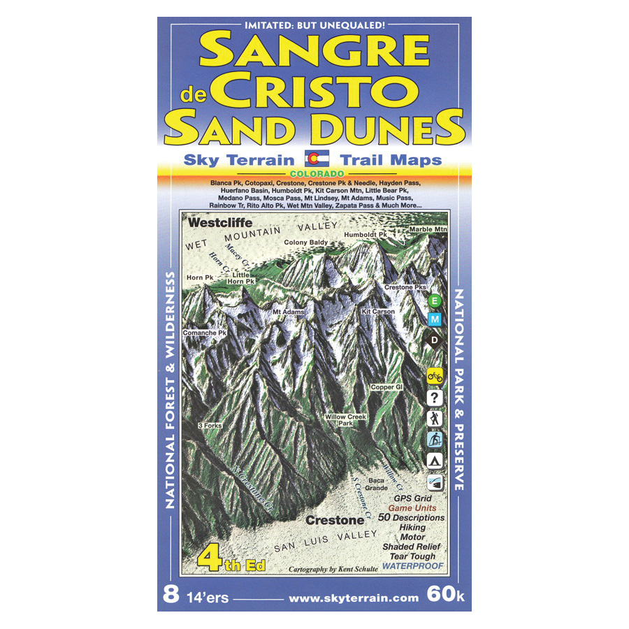
Sky Terrain 0-9665508-3-8 Trail Map, Blanca Peak, Comanche Peak, Crestone Needle, Crestone Peak

Promo Price:
Sky Terrain 0-9665508-3-8 Trail Map, Blanca Peak, Comanche Peak, Crestone Needle, Crestone Peak
The Sangre de Cristo mountain range rises steeply from two flanking valleys, San Luis and Wet Mountain, creating some of the most intense topography and ecology in Colorado. The 1,60,000 medium scale map covers hundreds of thousands of acres in the Rio Grande and San Isabel National Forest, from Hayden Pass south to Blanca Peak, Including the 14ers, Blanca Peak, Crestone Peak, Crestone Needle, Humboldt Peak, Kit Carson, Little Bear Peak, Mount Lindsey, 13ers, Electric Peak, Horn Peak, Rito Alto Peak, Mt Adams, Comanche Peak and dozens of others. Also mapped, the Huerfano Basin, San Luis Valley, Great Sand Dunes, Lakes of the Clouds, Hayden, Medano, Mosca and Music Pass, Rainbow Trail, Valley View Hot Springs and much more.
| Continental Coverage | Blanca Peak, Comanche Peak, Crestone Needle, Crestone Peak, Electric Peak, Great Sand Dunes, Hayden, Horn Peak, Humboldt Peak, Kit Carson, Lakes of the Clouds, Little Bear Peak, Medano, Mosca/Music Pass, Mount Lindsey, Mt Adams, Rainbow Trail, Rio Grande/San Isabel National Forest, Rito Alto Peak, San Luis Valley, The Huerfano Basin, Valley View Hot Springs |
- First topographic trail map of this stunning area
- First place cartography
- Waterproof and tear tough
- Hunter, hiker and climber favorite
- Symbolic trail ratings for easy, moderate and difficult levels
- 50 trail descriptions highlight key features, with UTM index, trail lengths, elevations
- Contours in easily counted intervals of 100ft
- UTM and latitude, longitude coordinates for use with GPS
- Advanced topographic shading and elevation tints reveal the stunning region in a never before seen light
- Newly mapped and named rock features and waterfalls