Boulder, CO · 2525 Arapahoe Ave
STORE HOURS:

Shop Products
- Gift Cards
- Apparel & Footwear
- Appliances
- Automotive
- Building Materials
- Cleaning
- Doors & Windows
- Electrical
- Hardware
- Fasteners
- Flooring
- Home Goods & Decor
- Heating, Cooling & Ventilation
- Holiday
- Lighting & Ceiling Fans
- Kitchen & Bath
- Lawn & Garden
- Paint
- Plumbing
- Outdoor Living
- Storage & Organization
- Pet & Wild Bird
- Sports & Recreation
- Tools
Services
Inspiration
About Us
Contact Us
Rewards
- Home
- Products
- Home Goods & Decor
- Office & Store Supplies
- Books, Maps & Planners
- Maps
- Latitude 40° 1-879866-20-0

Latitude 40°
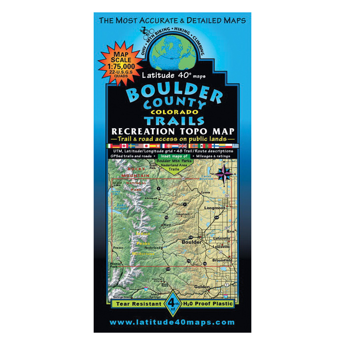
Latitude 40° Latitude 40° 1-879866-20-0 Trail Map, 39.3 in L, 25.2 in W, Boulder County
MPN: 1-879866-20-0
•
SKU: 102411675
• UPC: 831479002000
Store SKU:

Supplier SKU:
Customer Part Number:
Promo Price:
Volume Discounts
How Would You Like to Get It?
Store Pickup / Curbside
Check in-store availability · Ready same day
FREE
Ship to Me
Standard shipping · 5–7 business days
FREE
Local Delivery
Same-day in Boulder · Order before 2pm
$9.99
Need Help Choosing?
Our Green Vest experts can walk you through options or recommend a local pro.
Latitude 40° Latitude 40° 1-879866-20-0 Trail Map, 39.3 in L, 25.2 in W, Boulder County
Latitude 40° Latitude 40° Trail Map, Continental Coverage: Boulder County, 39.3 in Length, 25.2 in Width
| Continental Coverage | Boulder County |
| Length | 39.3 in |
| Width | 25.2 in |
- Map covers all or part of 22 USGS 1:24,000 7.5 min quad maps
- Contour interval 80 ft with shaded relief base
- Indian peaks wilderness
- Southern Rocky Mountain National Park
- James peak wilderness
- Boulder mountain parks and open space
- Nederland area trails
- Roosevelt national forest
- Color-coded elevation tinting
- Hundreds of miles of GPS-surveyed travel routes