Boulder, CO · 2525 Arapahoe Ave
STORE HOURS:

Shop Products
- Gift Cards
- Apparel & Footwear
- Appliances
- Automotive
- Building Materials
- Cleaning
- Doors & Windows
- Electrical
- Hardware
- Fasteners
- Flooring
- Home Goods & Decor
- Heating, Cooling & Ventilation
- Holiday
- Lighting & Ceiling Fans
- Kitchen & Bath
- Lawn & Garden
- Paint
- Plumbing
- Outdoor Living
- Storage & Organization
- Pet & Wild Bird
- Sports & Recreation
- Tools
Services
Inspiration
About Us
Contact Us
Rewards
- Home
- Products
- Home Goods & Decor
- Office & Store Supplies
- Books, Maps & Planners
- Maps
- Sky Terrain 0-9665508-5-4

Sky Terrain
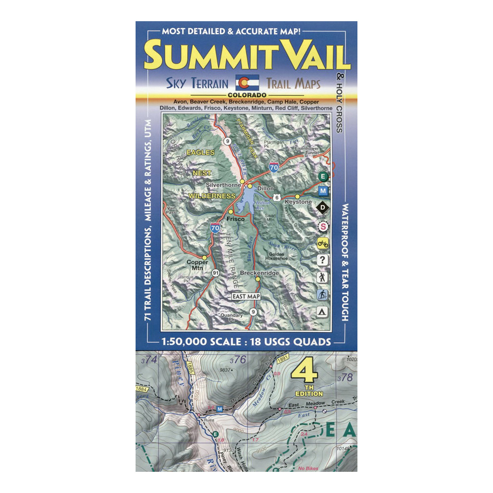
Sky Terrain 0-9665508-5-4 Trail Map, Avon, Beaver Creek, Boreas Pass, Breckenidge
MPN: 0-9665508-5-4
•
SKU: 102411731
• UPC: 9780966550856
Store SKU:

Supplier SKU:
Customer Part Number:
Promo Price:
Volume Discounts
How Would You Like to Get It?
Store Pickup / Curbside
Check in-store availability · Ready same day
FREE
Ship to Me
Standard shipping · 5–7 business days
FREE
Local Delivery
Same-day in Boulder · Order before 2pm
$9.99
Need Help Choosing?
Our Green Vest experts can walk you through options or recommend a local pro.
Sky Terrain 0-9665508-5-4 Trail Map, Avon, Beaver Creek, Boreas Pass, Breckenidge
Excellent map covers a total of 18 USGS quad maps (9 on each side). Areas of note include the TenMile Range, Boreas Pass, Breckenridge, Frisco, Quandary Peak, the Colorado Trail, Copper Mountain, Vail, Beaver Creek, Minturn, Red Cliff, Eagle River, Gore Creek, Dillon, Silverthorne, Avon, Edwards, Mount of the Holy Cross, Camp Hale, Jacque Peak, Searle Pass, French Pass, Loveland Pass, Keystone and much more.
| Continental Coverage | Avon, Beaver Creek, Boreas Pass, Breckenidge, Camp Hale, Copper Mountain, Dillon, Eagle River, Edwards, French Pass, Frisco, Gore Creek, Jacque Peak, Keystone, Loveland Pass, Minturn, Mount of the Holy Cross, Quandary Peak, Red Cliff, Searle Pass, Silverthorne, TenMile Range, the Colorado Trail, Vail |
- Waterproof, tear tough material for years of hands on use
- 71 trail descriptions, trail ratings and trail statistics
- Full UTM grid with 2K spacing for ready use with GPS
- Most accurate map for this area
- Most comprehensive map for this area
- Improved hydrological mapping
- Custom color tints create 3D effect
- Shaded relief, 100 ft contours